Zero-effort Integration with Esri ArcGIS® to Power Spatial Enterprise Asset Management, Maintenance, and Automation

Many organizations find accurate geospatial enterprise asset management (EAM) of fixed and mobile assets across internal and customer assets challenging. Leverage and connect your existing GIS investment in Esri’s ArcGIS software to power your asset management and maintenance, field service, and automation processes within a unified solution.

The Field Squared zero-effort integration to ArcGIS enables Esri customers to seamlessly access Esri’s Feature Services, base maps, overlays, and asset database within Field Squared—online and offline. With Field Squared and your ArcGIS data, operations managers can effectively manage their assets, mobile workforce, and field service from a single pane of glass.

Field Squared seamlessly works with Esri ArcGIS® Enterprise and ArcGIS Online® products.

Field Squared + Esri Integration


Watch this short video demo (under three minutes!) to see our zero-effort integration to Esri to power your enterprise asset management, maintenance and automation.

Key Benefits of the Field Squared Integration to Esri

esri-arcgis-asset-sync-field-squared

Realize effective enterprise asset management and maintenance with a real-time synchronization of Esri Feature Services, GIS maps, imagery and data

esri-arcgis-mobile-eam-icon-field-squared

Provide field technicians with access to your ArcGIS base maps (including any custom-built maps) and overlays directly from their mobile device in the field

esri-arcgis-eam-workflows-icon-field-squared

Automate asset management and maintenance workflows utilizing your Esri assets

Work-Order-Management-Icon-Field-Squared

Create and schedule work orders against your Esri assets

esri-arcgis-thematic-mapping-icon-field-squared
View Esri Feature Layers and Overlays on an interactive map and use thematic mapping for asset symbology to visualize your data or upload your own custom symbology library
Mobile-Offline-Sync-Engine-Icon-Field-Squared
Mobilize Esri data in the field—online and offline—syncing any changes when connectivity is restored

Key Features

esri-arcgis-integration-eam-scheduling-series-field-squared

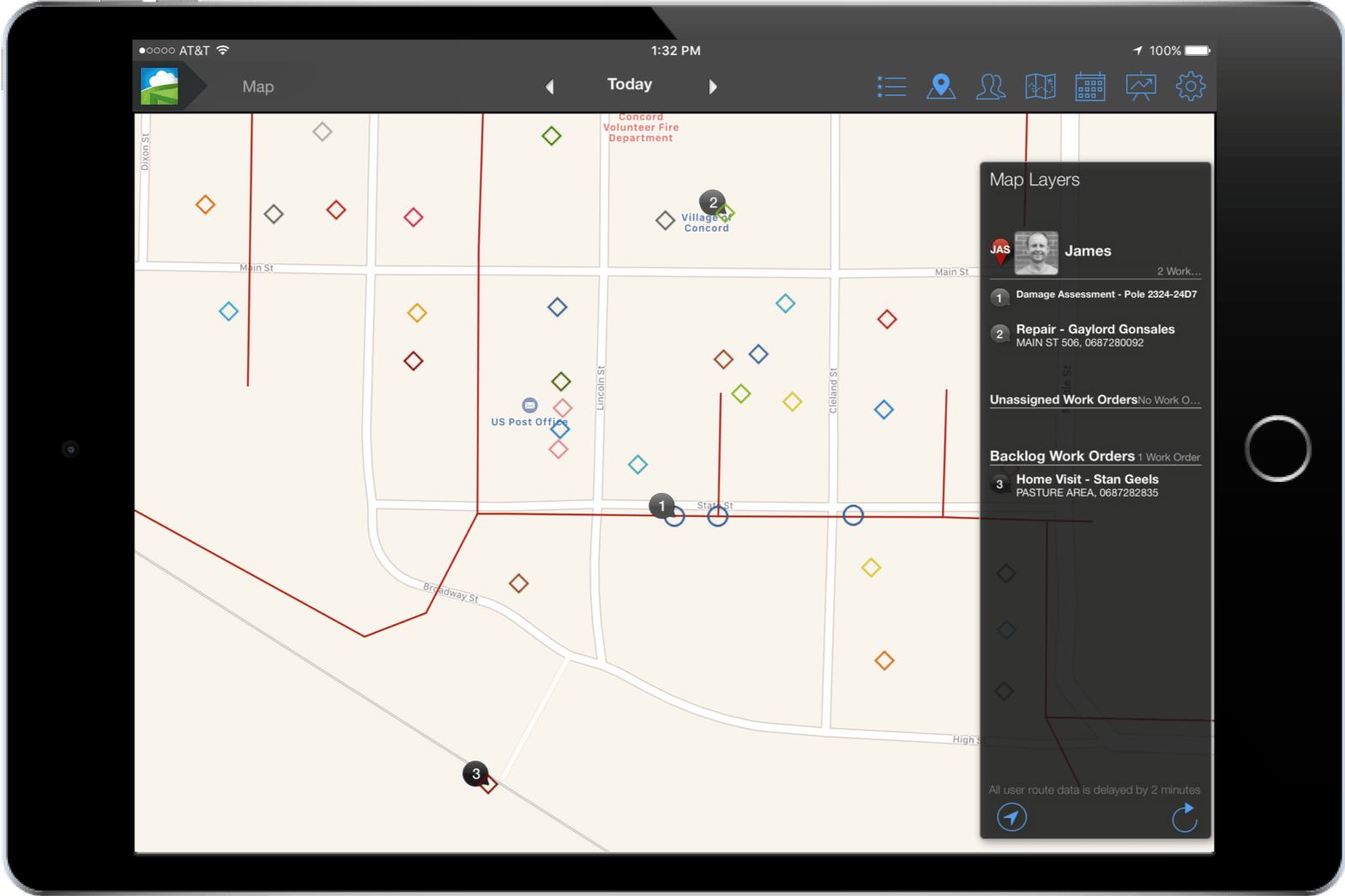
Schedule and Route Maintenance Work Orders Against Your Esri Asset Database

Across your Esri asset database, Field Squared provides a drag-and-drop scheduling solution to quickly route work orders. You can also select one or multiple assets within Field Squared to propose routes and assign tasks.

  • Display and view all your field assets on the Map
  • Schedule and manage one-off work orders against your Esri asset database
  • Create and schedule a recurring series of asset maintenance tasks
  • Plan and propose optimized routes for key activities, such as inspections
  • Assign asset work orders by skills matching, finding the nearest technician, or determining the next available technician
  • Draw boundaries around multiple assets to mass schedule, route, and assign work orders against assets

Field Squared supports nodal, linear, and polygonal geometry types for assets.

Simplify your scheduling process with our intuitive interface.

asset-accuracy-mobile-field-application

Redline Asset Updates from the Field – Online or Offline

Using the Field Squared Mobile Application, field technicians can visualize assets over Esri’s ArcGIS base maps and overlays as well as redline asset updates from their mobile device in the field—online or offline.

esri-silver-partner-field-squared-h-rev-580x148
As a leading field service management software provider, and one that understands the importance of geospatial asset management, Field Squared was a natural choice to partner with on this effort. Integrating ArcGIS and making the information available in the platform and mobile application directly in the field, is exciting for both Esri customers and Field Squared customers."

Matt Piper, Global Director Industry Solutions, and Industry Manager Electric and Gas at Esri
esri-arcgis-eam-field-service-collaboration-field-squared

Collaborate in Real-Time, From the Office to the Field

Collaborate on your Esri-based asset maintenance work orders in real-time via in-app messaging solutions. With Field Squared you can:

  • Send links to work orders, assets and customers via text message
  • Collaborate on ArcGIS redline updates between the operations manager and the field
  • Access a conversation history against your Esri assets to help audit maintenance tasks performed or overdue
enterprise-asset-field-data-capture-mobile-application

Capture Photos, Scan Barcodes, and More Against Your Esri Assets

With every type of Esri asset you maintain, chances are you have a different paper form the field technicians use for their work orders. Field Squared’s drag-and-drop digital form builder helps you convert any paper form to a digital version in a matter of minutes.

Our digital forms builder includes powerful out-of-the-box tools and logic to capture field and asset data against your Esri assets, such as:

  • Capture photos or scan barcodes – some of our customers take 100+ photos per work order form
  • Leverage native photo markup tools, allowing technicians to label problem areas or annotate issues against your Esri assets
  • Access math-based controls to allow complex functions and calculations (values, averages, sums, totals, percentages, etc.)
  • Capture signatures and initials

At the click of a button or via an automated workflow, forms can be emailed to personnel or customers upon completion. All changes are date- and time-stamped and include the GPS location as well as the name of the technician who made the changes.

esri-arcgis-eam-approval-workflow

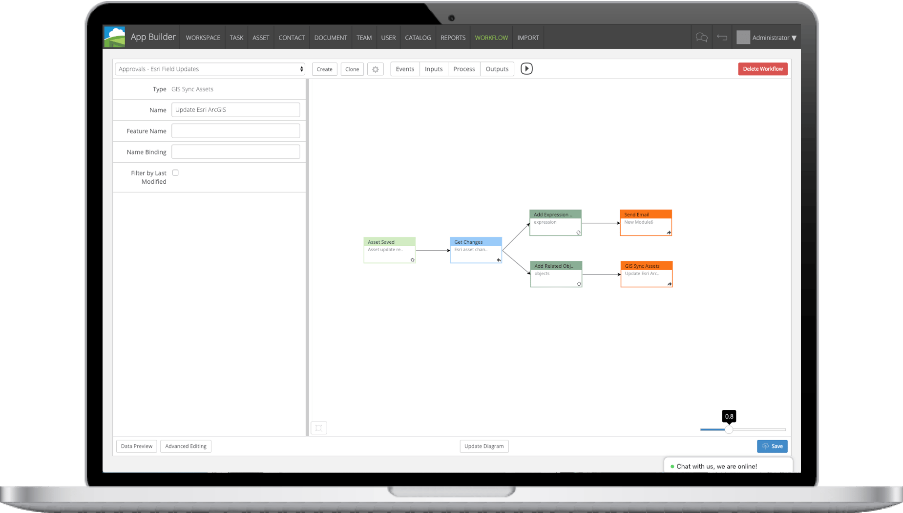
Create Automated Approval Workflows

The nature of asset maintenance and field service work requires enabling technicians to redline asset updates right from the field. But we understand that making changes to your Esri asset database is not something to be taken lightly.

With Field Squared, field updates can be part of automated approval workflows before they are synced back to your ArcGIS database, ensuring you’re in control of your data and any updates at all times.

Esri, the Esri logo, ArcGIS, ArcPad,(ets) are trademarks, service marks, or registered marks of Esri in the United States, the European Community, or certain other jurisdictions. Other companies and products or services mentioned herein are trademarks, service marks, or registered marks of their respective mark owners. Trademark provided under license from Esri.

Ready to Get Started?

Get in touch with us for a live demo.